Climate Change Graph


You will need: 120 multicoloured lollipop sticks (at least 10 sticks each of 6 colours), PowerPoint, lollipop.xls, blue tack or similar

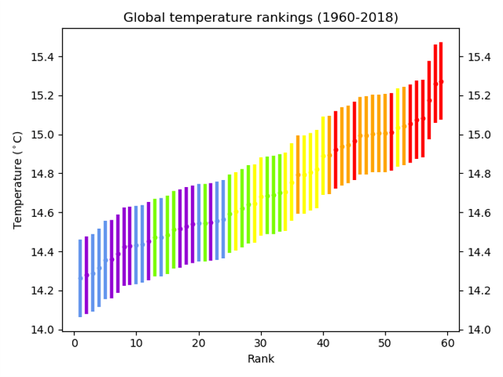
  1. Beforehand, mark on the middle of each lollipop stick. On each stick, write the year and the temperature for one of the data points in the spreadsheet (e.g. 1970 14.47), differentiating between global and CET data. Use a different coloured lollipop for each decade – so the 60s are all one colour etc.
  2. You’ll also need to print a blank graph – the spreadsheet supplied will work on A3 paper.
  3. Divide the students into two groups. Within each group, divide out the lollipop sticks.
  4. They should then work together to stick the sticks to the graphs in the right places.
  5. When they’ve finished, ask them to complete the table on the ppt.
  6. What does their graph show? What surprises them? What are the similarities and differences between the graphs?
  7. Next, they should take the sticks back off the graph and, within their groups, line the sticks up in temperature order with the coldest on the left and the warmest on the right.
  8. What does this show?

Climate Zones

Climate Zones

Background Information:

Our planet has several climatic zones; their classification is based on the temperature and precipitation over the seasons. The climatic zones can be simplified into:

Polar and Mountains – very cold and dry all year

Cool Temperate – cold winters and mild summers

Warm Temperate – mild winters, dry hot summers

Arid or Desert – dry, hot all year

Tropical – hot and wet all year

The climate of an area is affected by several factors: latitude (distance to the Equator), terrain, altitude (height)  and how far from the sea or ocean it is.

Materials:

Coloured pencils

Plasticine (white, blue, green and black)

A small ball

A lamp

Suggested activities:

Discuss the idea of different regions of the world experiencing different climates. Make a mind map using ideas from pupils about climate zones and the factors that may affect the climate of a region.

Climate Zones

Colour in the climate map below and colour it in according to the key.

N.B. Pupils may find the subsequent tasks easier if a logical colouring code is used like the one shown. Where hotter regions are highlighted in warm colours and cooler regions in cool colours, for simplicity the polar & mountain climate zones can stay white.

With the map coloured, pupils should look for patterns in the locations of the climate zones. Start by looking at the proximity to the equator and altitude with younger pupils. Explain that climate is in part affected by the absorption of heat from the sun. Different objects absorb heat at different rates (water is slower to heat and cool, land is much faster).

References/Resources:

Climate Zones: Internet Geography

Climates of the World: (Climate Zones) – detailed climate information for individual countries and areas within countries.

Practical Activities:

1. Modelling the Earth

You will need:

– Blue plasticine

– A small ball

– A heat lamp

Method: Make a model of the earth by covering a small ball with plasticine. Put the heat lamp a fair distance away from the ball – maybe 1m. Shine the heat lamp on the plasticine for a few minutes. Feel the difference in temperature between the ‘equator’ and the ‘poles’.

Results: The areas of the ball facing the lamp should feel much warmer than the areas pointing away – either the ‘poles’ or the ‘night’ side of the ball. When the surface of the Earth isn’t at right angles to the Sun, the Sun’s energy is spread over a wider area and it doesn’t heat up as much. This is the cause of much of the Earth’s weather. As the Earth orbits around the Sun, the Sun moves from being at right angles to the Tropic of Cancer to be overhead at the Tropic of Capricorn. This gives us seasons.

2. Modelling the Earth

You will need:

– White, blue and dark green plasticine
[Hint: Mixing some black with the green plasticine makes
a dark green that gives really good results]

– A small ball

– A sunny day

Method: Make a flat model of the earth by covering a piece of cardboard with white (Polar regions), blue (sea) and dark green (land) plasticine. Leave the map out in the Sun for 10 minutes. Feel the difference in temperature between the white and dark green areas.

Results: The darker areas should feel much warmer than the white poles. The colour of the area of land affects the ability to absorb light. Whiter regions (like the poles and mountains) reflect light and darker regions (like vast areas of tropical rainforest) absorb light and get warmer.

Earth
Climate Zones map

Transition Resources for Year 6/ Post SATS

Transition Resources for Year 6/Post SATS

These resources are designed to be used in one session with year 6 (10/ 11 year old) students. Although they will support numeracy, literacy and various other aspects of the curriculum, they are designed to prepare students for secondary school rather than support the year 6 curriculum.

There are 6 suggested activities. Although they are designed to be run sequentially, you may choose to use only some of the activities, or to supplement them with your own ideas.
It should be possible to use these activities with any class size.

Many people, including Ellie Highwood, Cristina Charlton-Perez, Helen Johnson and Laila Gohar, have contributed to these resources.

Guidance Notes – START HERE!

Activity 1 – the Difference between Weather and Climate

Powerpoint: Weather-or-Climate

Word Doc: Weather-or-Climate

Activity 2 – Climate Change Graphs

Powerpoint: Climate Change Picture

Excel: Lollipop

Activity 3 – Climate Change Lucky Dip

No resources required

Activity 4 – Weather Risk Game

Powerpoint: Weather Risk Game

Word Document: Money

Activity 5 – Flooding/ Floating Gardens

Powerpoint: Floating Garden Challenge

Activity 6 – Greenhouse Bulldog

No resources required

Resources for the Scottish Primary Curriculum

Early Level: People, Place and the Environment

While learning outdoors in differing weathers, I have described and recorded the weather, its effects and how it makes me feel and can relate my recordings to the seasons.

  • Names and talks about at least two different kinds of weather
  • Draws pictures to record the weather for three days
  • Describes how weather affects the activities they can undertake
  • Talks about how they feel about different kinds of weather
  • Describes which weather is likely to be related to which season

Suggested resources:

Make a weather tree like this one.

weather_symbols and more Weather symbols.

Seasons (this is an old resource, but also fits with the new curriculum).

Seasons from NGfL Cymru

First Level: People, Place and the Environment

By using a range of instruments, I can measure and record the weather and discuss how weather affects my life.

  • Uses instruments to measure and record at least two different weather elements, for example, temperature, rainfall, wind direction.

Suggested resources:

Pine Cone weather station.

How to make a wind meter, wind vane, rain gauge and much more.

Does rain always come from dark clouds?

Top 10 ideas for weather fieldwork.

By exploring climate zones around the world, I can compare and describe how climate affects living things.

  • Contributes to a discussion giving reasoned opinions on how the weather affects life.
  • Draws two conclusions about how living things adapt to the climate in any chosen area

Suggested resources:

An Island Home: Struay and where we live.

UK weather journey

Climate zone journey.

Sheet to record how the weather affects you.

World climates – holiday destinations.

An interactive GIS activity exploring extreme temperatures around the world


Second Level: People, Place and the Environment

I can describe the physical processes of a natural disaster (extreme weather event)
and discuss its impact on people and the landscape
.

  • Describes the causes of a natural disaster such as a volcano, earthquake or extreme weather event.
  • Describes the impact of the natural disaster giving at least three examples for people and one for the landscape. Impact can be positive or negative.

Suggested resources

Hurricane Katrina

2003 heatwave in Europe.

We’ve pulled together some resources about ex-hurricane Ophelia, bringing together information about tropical cyclones, depressions, anticyclones and air masses to explore the extremely unusual weather we experienced in October 2017 Ophelia.pptx.

Suggested Lessons: The Beast from the East

Lesson Outline

PowerPoint 1

PowerPoint 2

Card sort

UK map for air masses

Lesson 1 worksheet

Lesson 2 video questions

Lesson 2 weather observations workstation cards

You can find some older Scottish Curriculum linked ideas and lesson plans to enhance the learning and teaching of weather studies in the primary school here. These pre-date the Curriculum for Excellence.

UK Climate: Struay and Where We Live

Key Stage 1 Geography

How is Struay similar to, and different from, where we live?

Overview
In this series of activities children will be exploring similarities and differences between their own locality and the island of Coll (the fictionalised isle of Struay in the Katie Morag books). They will draw on what they have learnt already, in order to compare landscapes, weather, people and transport on Coll with their own locality. They will be introduced to the effects of climate on landscapes and that people design houses to keep out the weather.

Objectives
Children should learn:

  • that the world extends outside their locality
  • to recognise similarities and differences, and communicate them

Activity 1

Look at the slides and use for discussion about the weather and housing. Any information about houses and landscapes can then be used in activity two.

Lesson resources

Daily weather forecast for Coll.
An island home – Slides for use with activity 1.

Activity 2

Organise children into small groups:

  • groups working with support to make a model of Struay or their mainland locality, based on learning from earlier in this unit, and label main features.
  • groups working independently to make collage pictures of either Struay or mainland locality, and label main features.
  • groups working with the teacher to make models of Coll and mainland locality using maps and photographs, adding labels to main features.
  • encourage children to talk about similarities and differences between the two places.

Visit Coll Website.

You will need:
Maps of the Isle of Coll
Photos of Coll and locality
Photos of houses on Coll
and Katie Morag story books.

Activity 3

Ask the children to use the differentiated worksheets to make a list of ways where they live is the same and different to the isle of Struay, where Katie Morag lives.

An island home (High ability): PDF document comparing the Isle of Struay with where we live.
An island home (Low ability): PDF document comparing the Isle of Struay with where we live.

Web page reproduced with the kind permission of the Met Office.

Other Recommended Resources:

Some lesson ideas from the States including poetry, art and music.

Seasons resources from NGfL-Cymru

Weather symbols from the Met Office

Or how about making a weather tree to record the daily weather?

Top 10 Ideas for Teaching the Weather

Make a cloud in a bottle – use it to remind students about the water cycle, the fact that pressure is related to temperature, that the air has to cool for water droplets to form and that the energy released by water droplets forming is the energy source for developing storms. You can find some instructions here.

Cloud in a bottle

Teabag rocketDemonstrate a teabag rocket to remind students that warm air rises. You can find the instructions here.

Bubble chaseDo some weather fieldwork. Have a look at our top 10 ideas or the fieldwork page.


From when you start teaching the weather topic, to the end of the year, ask one member of the class each week to prepare a local weather forecast for the class. At the start, these might just be a summary of the weather forecast from the TV/ radio/ internet. By the end, they should show some understanding of air masses and depressions and why we are getting the weather we are.


Weather map

Global map of winds

snowIn the winter, particularly before Christmas, investigate the factors which determine Will it snow?.

Does it Always Rain from Dark Clouds?

CloudWheel Cutout

We have made a cloud wheel that can be cut out and used to identify clouds. Simply download the pdf, cut out the two circles, fasten together with a split pin and use to identify clouds.

Download Cloudwheel >>

CloudWheel Cut Out

Or, if you’d like a simpler version, use our Cloud bookmark.

Or, you can buy a laminated cloud identification key, produced in conjunction with the Field Studies Council, from our shop.

Weather Journey

Teacher’s Notes

Weather Zones Game Graphic

Overview

This is a “Weather” game for use with an upper KS1 class, looking at seasonal and daily weather patterns. Differentiation is easy within a class by using different sets of question cards. Print sets on different coloured card so that pupils are not aware that some of the questions are different. Weaker readers could be supported by a classroom assistant.

What to do

The game consists of a journey through different ‘stations’ in a classroom or hall. At each station the pupil (or group) must answer a question with 3 possible answers. Choosing the correct answer will lead to the next venue and the final one will take you back to where you started. Pupils do not know the order in which they have to visit the stations and, as it is circular, groups can start at different places. Incorrect answers result in penalties which can either send pupils back to somewhere they have already visited or describe another task. At each station pupils collect a piece of interesting information. These can then be used for extension work for the whole class or for the more able pupils.

Preparation

There are 8 stations, 2 alternative sets of question cards with three possible answers for each question. Print one set of questions for each student or group. The second set is easier.

Other Recommended KS1 Resources:

Some lesson ideas from the States including poetry, art and music.

Seasons resources from NGfL-Cymru

Weather symbols from the Met Office

Or how about making a weather tree to record the daily weather?

Climate Change Resources

Summary of Weather and Climate Links in the 2014 KS2 National Curriculum
Curriculum Links
Year 4 Scheme of Work Plants  Literacy
Year 3/ 4 Scheme of Work Climate zones
Year 5/6 Scheme of Work Climate zones Science – Light, Fossils

General Resources


Diamond Ranking sheet

Acknowledgements

The Climate Change Schools Resources were developed by the Climate Change Schools Project, based at the then Science Learning Centre in Durham and led by Krista McKinzey. A large number of teachers and schools in North East England were involved in their development.

They have subsequently been updated by the Royal Meteorological Society.