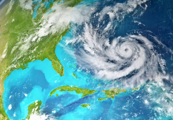
A Hurricane Direction Shift

The movement of a hurricane is modelled by vector h. 

It is moving at a speed of 20 kph, with the direction of 165˚ above the equator, when portrayed on a flat map of the Earth. 

a) Write h in component form.

[2 marks]

The hurricane makes landfall. Its movement is now modelled by vector l, \(\left( \frac{15\sqrt{3}}{2}\mathbf{\text{i}},\mathbf{\ }\frac{15}{2}\mathbf{j} \right)\).

b) Find the amount by which the hurricanes speed has decreased and state the hurricanes new direction.

[3 marks]

An Advancing Hurricane

A hurricane is heading from the Atlantic Ocean to Miami, Florida. If the centre of the hurricane goes within a 50 kilometre radius of the city centre, the city will sustain very severe damage.

A meteorologist models the city centre as a fixed particle located at the point (240 , 200). They then model the centre of the hurricane as travelling on a path relative to the city defined by \(y = kx + 20\). 

The unit of distance for the meteorologist’s coordinate system is kilometres.


a) Find the values of k such that the city does not sustain severe damage.

[8 marks]

b) State one limitation of the model.

[1 mark]

20. Tropical Cyclones

Weather and Climate: a Teachers’ Guide

Pathway: Extending Weather

Depressions – Microclimates – Urban Climates – Tropical Cyclones

Lesson overview: In this lesson we explore the structure, location and names for Tropical Cyclones as well as some of their potential impacts.

Tropical Cyclones are intense and extremely damaging storms.  Fuelled by the transfer of heat from the ocean to the atmosphere they can grow into some of the most destructive weather systems on Earth. Tropical cyclones need specific conditions to form and intensify.  These limit the locations in which Tropical Cyclones are able to form.  Called Tropical Cyclones anywhere in the world, they are classified as Typhoons in the North-West Pacific and Hurricanes in the Atlantic and North-East Pacific. A Tropical Cyclone has a distinctive structure, consisting of a clear central ‘eye’, surrounded by extensive cloud bands that spiral outwards and may be hundreds of kilometres long.  They can have severe impacts, causing coastal flooding and widespread damage to both the natural world and human infrastructure. As the climate changes, the most damaging Tropical Cyclones are expected to increase in intensity.

Learning objectives:

  • To understand what weather and hazards are associated with a Tropical Cyclone.

  • To be able to describe the structure of a Tropical Cyclone.

  • To be able to explain how and why Tropical Cyclones form.

Key Teaching Resources

Tropical Cyclones PowerPoint
Tropical Cyclones worksheet
Hurricane Dorian student data
Plotting Tropical Storm locations using GIS – video.

Teacher CPD/ Extended Reading

Read Tropical Cyclones_More for Teachers 

or watch

Alternative or Extension Resources

Typhoon Haiyan GIS activity and background information

Tropical Cyclone challenge game

Further Tropical Cyclone teaching resources

A Hurricane is Approaching: a listening exercise based on a recent National Hurricane Center podcast. 

Tropical storm tracker: grid reference plotting practice

Make a Tropical storm case study infographic using this basic template

A blank Tropical Cyclone case study sheet

Weather and Climate: a Teachers’ Guide

MetLink - Royal Meteorological Society
We use cookies on this site to enhance your user experienceBy clicking any link on this page you are giving your consent for us to set cookies. More info

By clicking any link on this page you are giving your consent for us to set cookies. More info