Global Atmospheric Circulation
One part of the Earth’s surface is always facing the Sun – it varies between the Tropic of Cancer at the June solstice to the Tropic of Capricorn at the December solstice.
This latitude receives the most energy per unit surface area, and is known as the Inter-Tropical Convergence Zone or ITCZ. Here, the air rises, hits the top of the troposphere and spreads out towards the poles. The Coriolis Effect means that this poleward moving air is deflected ever more to the right, becoming westerly (remember we name winds by the direction they are blowing from) and eventually sinking in the sub-tropics and returning towards the ITCZ – this time becoming easterly and giving us the Trade Winds. The whole circulation is known as the Hadley Cell (Figure 1).
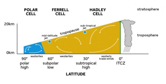
FIGURE 1: A CROSS SECTION THROUGH THE ATMOSPHERE, SHOWING AIR RISING AND FORMING DEEP CLOUDS, AT THE INTERTROPICAL CONVERGENCE ZONE AND SPREADING POLEWARDS, AND THE HADLEY, FERREL AND POLAR CELLS.
Similarly, at the poles where the ground surface is coldest, the air sinks, spreads out towards the Tropics, is deflected to the right and eventually rises and completes a circulation – the Polar Cell.
In between, lies the ‘Ferrel cell’, characterised by surface westerlies and rising motion around 60°. This cell is actually the net product of all the mid-latitude weather systems. Figure 2 shows the 3-Dimensional circulation of the atmosphere.

FIGURE 2: IDEALISED REPRESENTATION OF THE GENERAL CIRCULATION OF THE ATMOSPHERE SHOWING THE POSITIONS OF POLAR FRONT; ITCZ (INTER TROPICAL CONVERGENCE ZONE); SUBTROPICAL JETS (STJ) POLAR FRONT JETS (PFJ)
It’s worth noting that, if the Earth wasn’t rotating, we’d have just one ‘thermally direct’ cell with air rising at the ITCZ and sinking at the poles where the ground is coldest.
The polar and sub-tropical High pressure areas are the source regions for air masses.
Teaching Resources
Global atmospheric circulation from Weather and Climate: a Teachers’ Guide.
Data and Image Sources
Take a look at the current air flow on the surface of the Earth, can you make out the Trade Winds? Do they tend to be stronger over land or ocean? Where is the ITCZ at the moment?