Find out about how to borrow weather instruments in order to be able to carry out a microclimate investigation with your school here, or more about urban heat islands here.
What are microclimates?
What are the different types of microclimates?
What is an urban microclimate?
Urban precipitation
Smog
Urban winds
What are microclimates?
 A microclimate is the distinctive climate of a small-scale area, such as a garden, park, valley or part of a city. The weather variables in a microclimate, such as temperature, rainfall, wind or humidity, may be subtly different from the conditions prevailing over the area as a whole and from those that might be reasonably expected under certain types of pressure or cloud cover. Indeed, it is the amalgam of many, slightly different local microclimates that actually makes up the microclimate for a town, city or wood.
It is these subtle differences and exceptions to the rule that make microclimates so fascinating to study, and these notes help to identify and explain the key differences which can be noticed by ground-level observations.
What are the different types of microclimates?
In truth, there is a distinctive microclimate for every type of environment on the Earth’s surface, and as far as the UK is concerned they include the following:
Upland regions
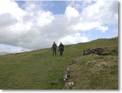 Upland areas have a specific type of climate that is notably different from the surrounding lower levels. Temperature usually falls with height at a rate of between 5 and 10 °C per 1000 m, depending on the humidity of the air. This means that even quite modest upland regions, such as The Cotswolds, can be significantly colder on average than somewhere like the nearby Severn Valley in Gloucestershire.
Occasionally, a temperature inversion can make it warmer above, but such conditions rarely last for long. With higher hills and mountains, the average temperatures can be so much lower that winters are longer and summers much shorter. Higher ground also tends to be windier, which makes for harsher winter weather. The effect of this is that plants and animals are often different from those at low levels.
Hills often cause cloud to form over them by forcing air to rise, either when winds have to go over them or they become heated by the sun. When winds blow against a hill-side and the air is moist, the base of the cloud that forms may be low enough to cover the summit. As the air descends on the other (lee) side, it dries and warms, sometimes enough to create a föhn effect. Consequently, the leeward side of hills and mountain ranges is much drier than the windward side. The clouds that form due to the sun’s heating sometimes grow large enough to produce showers, or even thunderstorms. This rising air can also create an anabatic wind on the sunny side of the hill. Sunshine-facing slopes (south-facing in the Northern Hemisphere, north-facing in the Southern Hemisphere) are warmer than the opposite slopes.
Apart from temperature inversions, another occasion when hills can be warmer than valleys is during clear nights with little wind, particularly in winter. As air cools, it begins to flow downhill and gathers on the valley floor or in pockets where there are dips in the ground. This can sometimes lead to fog and/or frost forming lower down. The flow of cold air can also create what is known as a katabatic wind.

Coastal regions
The coastal climate is influenced by both the land and sea between which the coast forms a boundary. The thermal properties of water are such that the sea maintains a relatively constant day to day temperature compared with the land. The sea also takes a long time to heat up during the summer months and, conversely, a long time to cool down during the winter. In the tropics, sea temperatures change little and the coastal climate depends on the effects caused by the daytime heating and night-time cooling of the land. This involves the development of a breeze from off the sea (sea breeze) from late morning and from off the land (land breeze) during the night. The tropical climate is dominated by convective showers and thunderstorms that continue to form over the sea but only develop over land during the day. As a consequence, showers are less likely to fall on coasts than either the sea or the land.
Around the Poles, sea temperatures remain low due to the presence of ice, and the position of the coast itself can change as ice thaws and the sea re-freezes. One characteristic feature is the development of powerful katabatic winds that can sweep down off the ice caps and out to sea.
In temperate latitudes, the coastal climate owes more to the influence of the sea than of the land and coasts are usually milder than inland during the winter and cooler in the summer. However, short-term variations in temperature and weather can be considerable. The temperature near a windward shore is similar to that over the sea whereas near a leeward shore, it varies much more. During autumn and winter, a windward shore is prone to showers while during spring and summer, showers tend to develop inland. On the other hand, a sea fog can be brought ashore and may persist for some time, while daytime heating causes fog to clear inland. A lee shore is almost always drier, since it is often not affected by showers or sea mist and even frontal rain can be significantly reduced. When there is little wind during the summer, land and sea breezes predominate, keeping showers away from the coast but maintaining any mist or fog from off the sea.
Forests
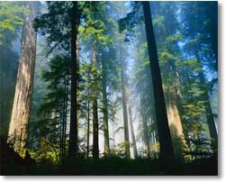 Tropical rainforests cover only about 6% of the earth’s land surface, but it is believed they have a significant effect on the transfer of water vapour to the atmosphere. This is due to a process known as evapotranspiration from the leaves of the forest trees. Woodland areas in more temperate latitudes can be cooler and less windy than surrounding grassland areas, with the trees acting as a windbreak and the incoming solar radiation being ‘filtered’ by the leaves and branches. However, these differences vary depending on the season, i.e. whether the trees are in leaf, and the type of vegetation, i.e. deciduous or evergreen. Certain types of tree are particularly suitable for use as windbreaks and are planted as barriers around fields or houses.
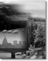
Urban regions
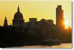 These are perhaps the most complex of all microclimates. With over 75% of the British population being classed as urban, it is no surprise that they are also the most heavily studied by students of geography and meteorology. Therefore, the rest of these notes focus on the various elements that constitute an urban microclimate.
What is an urban microclimate?
The table below summarises some of the differences in various weather elements in urban areas compared with rural locations.
| Sunshine duration | 5 to 15% less |
| Annual mean temperature | 0.5-1.0 °C higher |
| Winter maximum temperatures | 1 to 2 °C higher |
| Occurrence of frosts | 2 to 3 weeks fewer |
| Relative humidity in winter | 2% lower |
| Relative humidity in summer | 8 to 10% lower |
| Total precipitation | 5 to 10% more |
| Number of rain days | 10% more |
| Number of days with snow | 14% fewer |
| Cloud cover | 5 to 10% more |
| Occurrence of fog in winter | 100% more |
| Amount of condensation nuclei | 10 times more |
Urban heat islands
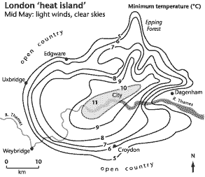 Marked differences in air temperature are some of the most important contrasts between urban and rural areas shown in the table above. For instance, Chandler (1965) found that, under clear skies and light winds, temperatures in central London during the spring reached a minimum of 11 °C, whereas in the suburbs they dropped to 5 °C.
Indeed, the term urban heat island is used to describe the dome of warm air that frequently builds up over towns and cities.
The formation of a heat island is the result of the interaction of the following factors:
- the release (and reflection) of heat from industrial and domestic buildings;
- the absorption by concrete, brick and tarmac of heat during the day, and its release into the lower atmosphere at night;
- the reflection of solar radiation by glass buildings and windows. The central business districts of some urban areas can therefore have quite high albedo rates (proportion of light reflected);
- the emission of hygroscopic pollutants from cars and heavy industry act as condensation nuclei, leading to the formation of cloud and smog, which can trap radiation. In some cases, a pollution dome can also build up;
- recent research on London’s heat island has shown that the pollution domes can also filter incoming solar radiation, thereby reducing the build up of heat during the day. At night, the dome may trap some of the heat from the day, so these domes might be reducing the sharp differences between urban and rural areas;
- the relative absence of water in urban areas means that less energy is used for evapotranspiration and more is available to heat the lower atmosphere;
- the absence of strong winds to both disperse the heat and bring in cooler air from rural and suburban areas. Indeed, urban heat islands are often most clearly defined on calm summer evenings, often under blocking anticyclones.

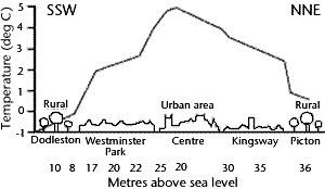
The precise nature of the heat island varies from urban area to urban area, and it depends on the presence of large areas of open space, rivers, the distribution of industries and the density and height of buildings. In general, the temperatures are highest in the central areas and gradually decline towards the suburbs. In some cities, a temperature cliff occurs on the edge of town. This can be clearly seen on the heat profile below for Chester.
Urban precipitation
As noted previously, the greater presence of condensation nuclei over urban areas can lead to cities being wetter and having more rain days than surrounding rural areas. Indeed, it was often said that Rochdale, the famous mill town, had significantly smaller amounts of rain on Sundays when the town’s factories were closed.
However, other factors play a major role, especially the heat islands. These can enhance convectional uplift, and the strong thermals that are generated during the summer months may serve to generate or intensify thunderstorms over or downwind of urban areas. Storms cells passing over cities can be ‘refuelled’ by contact with the warm surfaces and the addition of hygroscopic particles. Both can lead to enhanced rainfall, but this usually occurs downwind of the urban area.
Smog
Smogs were common in many British cities in the late 19th and early 20th centuries, when domestic fires, industrial furnaces and steam trains were all emitting smoke and other hygroscopic pollutants by burning fossil fuels. The smogs were particularly bad during the winter months and when temperature inversions built up under high pressure, causing the pollutants to become trapped in the lower atmosphere and for water vapour to condense around these particles.
One of the worst of these ‘pea-soup fogs’ was the London smog of the winter of 1952/53. Approximately 4,000 people died during the smog itself, but it is estimated that 12,000 people may have died due to its effects. As a result, the Clean Air Act of 1956 was introduced to reduce these emissions into the lower atmosphere. Taller chimney stacks and the banning of heavy industry from urban areas were just two of the measures introduced and, consequently, fewer smogs were recorded in the UK during the 1960s and 1970s.
Research in the 1990s has shown, however, that another type of smog – photochemical – is now occurring in some urban areas as a result of fumes from car exhausts and the build up of other pollutants in the lower atmosphere which react with incoming solar radiation. The presence of a brown-coloured haze over urban areas is an indication of photochemical smog, and among its side effects are people experiencing breathing difficulties and asthma attacks.
Urban winds
Tall buildings can significantly disturb airflows over urban areas, and even a building 100 metres or so high can deflect and slow down the faster upper-atmosphere winds. The net result is that urban areas, in general, are less windy than surrounding rural areas.
However, the ‘office quarter’ of larger conurbations can be windier, with quite marked gusts. This is the result of the increased surface roughness that the urban skyline creates, leading to strong vortices and eddies. In some cases, these faster, turbulent winds are funnelled in between buildings, producing a venturi effect, swirling up litter and making walking along the pavements quite difficult.
Web page reproduced with the kind permission of the Met Office