Anticyclones, Depressions and Fronts
By the end of the lesson, you will be able to:
- Understand the characteristics of depressions and fronts and the sequence of associated weather
- Understand the characteristics of anticyclones and the contrast between those in summer and in winter.
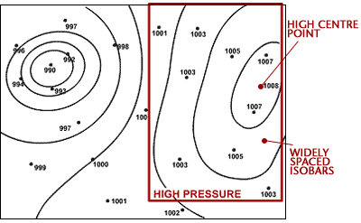
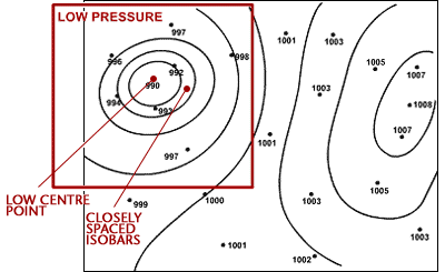
Part A – Anticyclones and Depressions
Part C – Life cycle of a Depression
Part D – Depression cross-section and weather sequence
Part B
Anticyclones, Depressions and Fronts
Part B – Fronts
A front is a boundary between two different types of air masses, these are normally warm moist air masses from the tropics and cooler drier air masses from polar regions. Fronts move with the wind so over the UK they normally move from west to east. The notes below provide information about the most common types of fronts. The descriptions given apply to active well developed fronts, weaker fronts may not display all the characteristics or they may be less well defined.
Warm fronts
A warm front indicates that warm air is advancing and rising up over the colder air. This is because the warm air is ‘lighter’ or less dense, than the cold air. Therefore warm fronts occur where warmer air is replacing cooler air at the surface. As the warm front approaches there is a gradual deterioration in the weather. Clouds gradually lower from higher cirrus, through altostratus, to stratus and nimbostratus at the front. There is often a prolonged spell of rainfall which is often heavy. Behind the warm front the rain becomes lighter, turns to drizzle or ceases, but it remains cloudy. Temperatures rise behind the warm front and winds turn clockwise, also known as a wind ‘veer’. Pressure falls steadily ahead of and during the passage of the warm front, but then rises slowly after its passage.
The diagram below shows the formation of a warm front in diagrammatic form.
The diagram below shows a cross section through a warm front, with associated cloud, temperature and weather changes.
Cold fronts
A cold front indicates that cold air is advancing and pushing underneath warmer air at the surface. This occurs because the cold air is ‘heavier’ or denser than the warm air. Therefore cold fronts occur where cooler air is replacing warmer air at the surface. The passage of weather associated with a cold front is much shorter lived than that with a warm front. As there is often a lot of cloud in the warmer air ahead of the cold front, there is often little indication of the approaching cold front. As the front passes temperatures fall and there is often a short spell of very heavy rain, sometimes with inbedded thunderstorms and cumulonimbus clouds. Behind the front the weather is much brighter with broken clouds but occasional showers. Winds veer with the passage of the cold front and are often strong and gusty, especially near showers. Pressure rises throughout the approach and passage of the cold front.
The diagram below shows the formation of a cold front in diagrammatic form.
The diagram below shows a cross section through a cold front, with associated cloud, temperature and weather changes.
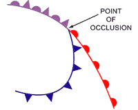
Occlusions
In a mature depression the warm front normally precedes the cold front. Cold fronts generally travel much quicker than warm fronts, and eventually it will catch up with the warm front. Where the two fronts meet, warm air is lifted from the surface and an occlusion is formed. An occlusion can be thought of as having similar characteristics to both warm and cold fronts. The weather ahead of an occlusion is similar to that ahead of a warm front, whilst the weather behind is similar to that behind a cold front.
The diagrams below depict the formation of an occlusion.
The diagram below shows the occlusion in cross section.
What to do next
Now you can go on to Part C – Life cycle of a Depression.
Anticyclones, Depressions and Fronts
Part C – Life cycle of a Depression
A Norwegian scientist called Vilhelm Bjerknes devised a simple model which described how depressions developed from the meeting of warm and cold air. The model had four stages which are detailed below.Origin and infancy
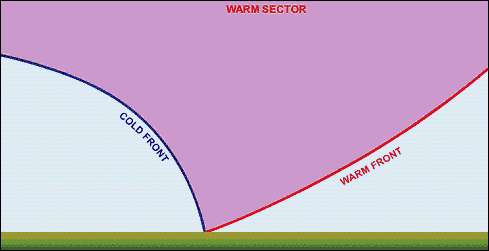
Initially a warm air mass such as one from the tropics, meets a cooler air mass, such as one from the polar regions. Depressions which affect the UK normally originate over the Atlantic Ocean.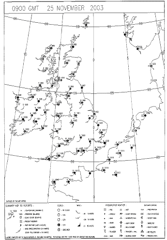 Maturity
The warm air rises up over the colder air which is sinking. A warm sector develops between the warm and cold fronts. The mature stage of a depression often occurs over the UK.
Maturity
The warm air rises up over the colder air which is sinking. A warm sector develops between the warm and cold fronts. The mature stage of a depression often occurs over the UK.
Occlusion
The cold front travels at around 40 to 50 miles per hour, compared to the warm front which travels at only 20 to 30 miles per hour. Therefore the cold front eventually catches up with the warm front. When this occurs an occlusion is formed.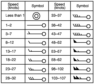
Death
Eventually the frontal system dies as all the warm air has been pushed up from the surface and all that remains is cold air. The occlusion dies out as temperatures are similar on both sides. This stage normally occurs over Europe or Scandinavia. What to do next Now you can go on to Part D – Depression cross-section and weather sequence.Anticyclones, Depressions and Fronts
Part D – Depression cross-section and weather sequence
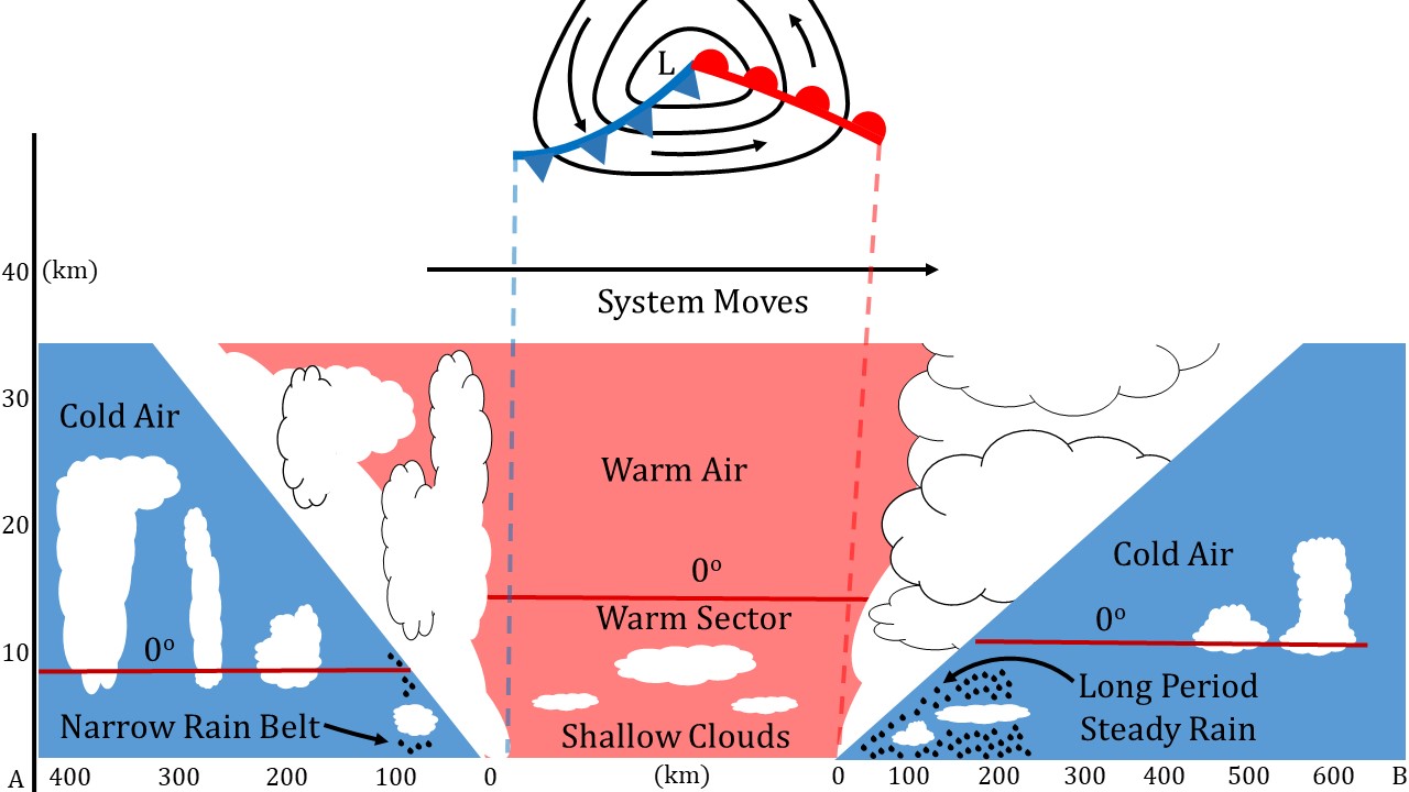
Cross-section through a classic Depression
Most depressions have a warm and cold front, more mature depressions may also have an occluded front. The diagram below shows a cross-section through a depression, showing the warm and cold fronts and an indication of the associated weather.
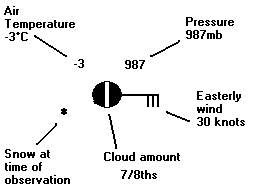
| ||||||||||||||||||||||||||||||||||||||||||
What to do next
Using this information on the passage of depressions you should now be able to complete worksheet 3, and worksheet 4.
Web page reproduced with the kind permission of the Met Office