The vertical structure of the atmosphere
The Earth’s atmosphere is most commonly divided into four isothermal layers or ‘spheres’: troposphere, stratosphere, mesosphere and thermosphere.
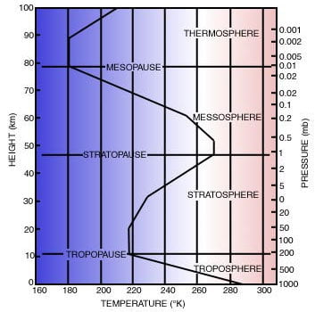 Fig 1: Vertical temperature profile of the ICAO Standard Atmosphere
Each layer is characterised by a uniform change in temperature with increasing altitude. In some layers there is an increase in temperature with altitude, whilst in others it decreases with increasing altitude. The top or boundary of each layer is denoted by a ‘pause’ where the temperature profile abruptly changes, as shown in Figure 1.
Troposphere
The troposphere contains about 80% of the atmosphere and is the part of the atmosphere in which we live, and make weather observations. In this layer, average temperatures decrease with height. This is known as adiabatic cooling, i.e. a change in temperature caused by a decrease in pressure. Even so, it is still more prone to vertical mixing by convective and turbulent transfer, than other parts of the atmosphere. These vertical motions and the abundance of water vapour make it the home of all important weather phenomena.
The troposphere’s thermal profile is largely the result of the heating of the Earth’s surface by incoming solar radiation. Heat is then transferred up through the troposphere by a combination of convective and turbulent transfer. This is in direct contrast with the stratosphere, where warming is the result of the direct absorption of solar radiation.
The troposphere is around 16 km high at the equator, with the temperature at the tropopause around -80 °C. At the poles, the troposphere reaches a height of around 8 km, with the temperature of the tropopause around -40 °C in summer and -60 °C in winter.
Therefore, despite the higher surface temperatures, the tropical tropopause is much cooler than at the poles.
Stratosphere
In contrast to the troposphere, temperatures in the stratosphere rise with increasing altitude. Another distinctive feature of the stratosphere is the absorption of ultraviolet radiation by ozone (O3). This is greatest around 50 km, which is where the stratopause occurs. Temperatures reach a maximum here, and according to latitude and season, they range from -30 °C over the winter pole to +20 °C over the summer pole.
As well as a noticeable change in temperature, the move from the troposphere into the stratosphere is also marked by an abrupt change in the concentrations of the variable trace constituents. Water vapour decreases sharply, whilst ozone concentrations increase. These strong contrasts in concentrations are a reflection of little mixing between the moist, ozone-poor troposphere and the dry, ozone-rich stratosphere.
Despite the dryness of the stratosphere, some clouds have developed in winter months over high latitudes at altitudes between 17 and 30 km, stretching into the stratosphere. They generally display iridescence and are known as nacreous clouds.
The stratosphere extends up to around 48 km above the surface, and together with the troposphere, they account for 99.9% of the Earth’s atmosphere.
Mesosphere
Temperatures in the mesosphere decrease with height from the stratopause up to the mesopause, at around 85 km. Temperatures at the mesopause vary from as low as -120 °C at high latitudes in summer to -50 °C in winter. The cold summer temperatures and the warm winter temperatures are therefore a reverse of what happens at the stratopause.
As in the troposphere, the unstable profile means that the vertical motions are not inhibited. During the summer, there is enough lifting to produce clouds in the upper mesosphere at high latitudes – it is then that the stratopause achieves its highest temperature due to the optimum amount of solar radiation being received. These clouds are known as noctilucent, and are very thin. Even so, they are visible against a night sky when the sun is at a small angle below the horizon, so that they are high enough to be in sunlight. By using triangulation techniques, these clouds have been estimated to form up to 80 km above the surface.
Thermosphere
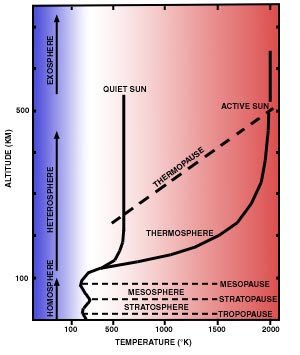
The thermosphere extends upwards to altitudes of several hundred kilometres, where temperatures range from 500 K to as high as 2,000 K (Kelvin), depending on the degree of solar activity. The temperature changes between day and night amount to hundreds of degrees. The height of the thermopause varies from about 200 to 500 km, again depending on solar activity. Above 500 km temperatures are very difficult to define. Molecules are so widely spaced that they move independently, and there is no reason why their temperatures should be the same.
Unequal heating of the Earth’s surface
The relationship between the Earth and the Sun
There are many reasons which explain the unequal or differential heating from pole to pole of the Earth’s surface. The principal factor is the change in the Sun’s elevation due to the latitude and season. The Earth orbits the Sun approximately every 365 days. The Earth also rotates on its own axis once every 24 hours, giving us our daily and diurnal variation. As the Earth orbits the Sun, we get seasonal variations which result from changes in the amount of solar radiation reaching each part of the Earth, hence the variation between daylight and darkness throughout the year.
The Earth’s rotational axis is not vertical, but tilted at an angle of 23.5° to the vertical. Because of this the apparent motion of the overhead sun appears to move from the Tropic of Cancer (23.5° N) at northern hemisphere midsummer (21-22 June) to the Tropic of Capricorn (23.5° S) at northern mid winter (21-22 December). Summer/winter alternate as the northern and southern hemispheres are alternately tilted towards/away from the Sun.
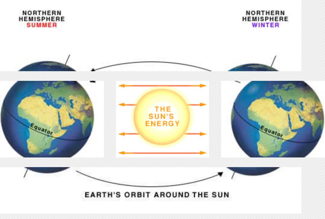
If the Earth did not tilt on its axis, there would be no seasons at all, and most places, except the poles, would have 12 hours daylight each day throughout the year.
Every year the polar areas have at least one complete 24-hour period of darkness and one of daylight. In theory, the poles themselves should have six months of daylight followed by six months of darkness. In reality, this is not the case because some light from the Sun is bent towards the Earth making nights slightly shorter than they otherwise would be.
The equatorial regions do not really have seasons as we know them, as the relative position of the overhead Sun does not change significantly enough throughout the year.
At high latitudes the Sun’s rays reach the Earth’s surface more obliquely, so that the energy is spread over a greater surface area. In addition, more radiation is lost to scattering and absorption as the path through the atmosphere is longer. In the winter at high latitudes, days are short with continuous darkness in polar regions at mid-winter. Here there is a net loss of outgoing long-wave radiation into space with no incoming short-wave radiation to compensate. Nearer the equator, where the sun is near the vertical, at midday the sun’s rays strike with greater intensity, as shown in Figure 4.

A and B are equal and parallel clusters of light rays from the Sun. At A the Sun is overhead and the rays are at right angles to the atmosphere and the surface of the Earth. At B the rays approach the atmosphere from an angle and consequently have more atmosphere to travel through – distance A compared with distance B on Figure 4. Also, being at an angle illuminates a larger surface area of the Earth’s surface. Effectively the energy arriving has to be distributed over a greater area from source B compared with source A.
Effective use of incoming radiation
Another contributory factor in determining the weather and climate is the amount of the Sun’s energy which is absorbed by the Earth’s surface. The amount of reflection by the Earth’s surface is known as albedo. The lower the albedo of a particular surface the more solar radiation is absorbed. The polar ice sheets reflect incoming short-wave radiation so effectively that there is little heat available for a rise in temperature. Deserts, on the other hand, reflect only about 25% of radiation from the Sun and consequently the high rate of absorption means they can get very hot.
| TYPICAL ALBEDOS (%) | |
| Surface type | Albedo |
| Water (solar elevation 90°) | 3 |
| Water (solar elevation 30°) | 7 |
| Water (solar elevation 10°) | 24 |
| Sea ice | 30-40 |
| Fresh snow | 75-95 |
| Old snow | 55 |
| Forests | 5-10 |
| Dry sand | 20-30 |
| Dark soil | 5-15 |
| Grassland | 15-20 |
| Thin cloud | 35-50 |
| Thick cloud | 70-90 |
The amount of albedo can also depend on the angle of the Sun’s rays. For example when the Sun is high in the sky, the sea absorbs much of the radiation, when it is low in the sky the sea acts rather like a mirror, reflecting most of the incoming radiation. More solar radiation reaches the atmosphere above the summer pole during the continuous daylight period than reaches the atmosphere at the equator. The high albedo and low angle of the sun ensure that this is spread out over a larger angle than at the equator, reducing its heating effect, and a significant proportion of what reaches the surface is reflected back into space. Total planetary albedo is estimated at around 40%, so four tenths of the incoming radiation is reflected back into space.
Transfer of energy
The next question which needs answering is why do the poles get colder and colder, whilst the equator gets hotter and hotter? The answer involves the presence of water and the general circulation of air.
Water
Without water in the atmosphere there would be no weather, no rain, no snow, or even clouds. Water, in the form of water vapour in the atmosphere, or currents in the ocean is responsible for transferring heat energy from the equator towards the poles.
Water is the only substance to occur naturally in the atmosphere as either a solid (ice), liquid (water, rain) and a gas (water vapour). The energy absorbed and released during its changes from one state to another is the main method of energy transfer in the atmosphere.
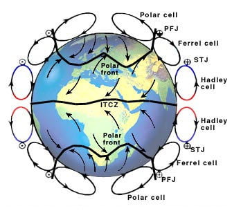
Atmospheric cells
High temperatures over the equator and low temperatures over the poles result in a series of circulatory cells which form part of a theory known as the tricellular model. There is an added complication to this model in that the Earth is rotating. This has the effect of splitting the circulation between the equator and the poles into three cell zones – the Hadley, Ferrel and Polar (see Figure 5).
Within the equatorial region, surface air rises and flows towards the poles. At about 30° latitude, the air starts to descend, with the returning branch flowing at the surface toward the equator. However, the Coriolis force acts upon this surface flow, deflecting the air to the right (east) in the northern hemisphere and to the left (west) in the southern hemisphere. The resulting surface winds are named the trade winds, because of the important role they played in opening up the New World to trade. The cell in the tri-cellular model, closest to the equator, is named after the English meteorologist, George Hadley (1685-1768) who first postulated the existence of the cell to explain these trade winds. In doing so, he clearly recognised the importance of what much later was to be named the Coriolis force.
Between the Hadley cell and the Polar cell is the Ferrel Cell – named after William Ferrel, an American meteorologist. This cell lies between about 30° to about 60° latitude, and it is not directly thermally driven (as it is in the opposite direction to the Hadley cell and the Polar cell). It represents an area of cyclonic disturbances that intermittently transport heat and westerly momentum between the tropical cell and polar regions. The British Isles lie within the area of influence of the Ferrel cell.