A snowy spell of weather affected most the UK from 14 to 26 January 2013.
This period brought the most widespread and prolonged snowfall in the UK since November and December 2010 and led to travel disruption and school closures across many parts of the country. All areas, apart from the far southwest of England, were affected.
Meteorological situation
Snow affected eastern Scotland and the north and east England on the 14 and 15 January.
10 cm was recorded in places. A cold few days followed and temperatures as low as -13.1 °C were recorded at Marham in Norfolk on 16 January.
On the 18 January a series of Atlantic weather fronts attempted to introduce milder air to the UK. With high pressure centred over Scandinavia, cold air from the east had been affecting the UK. With these fronts encountering such cold air, the precipitation fell as snow.
Image 1 below is the weather chart for 6am 18 January.
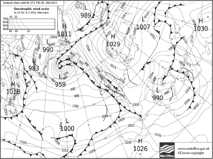
Image 2 below shows the weather radar for the same time and shows where the snow was falling. On the weather radar image the brighter colours show heavier snowfall. To see the weather radar intensity colour scheme go to www.metoffice.gov.uk/weather/uk/radar/
25 cm of snow fell across parts of south Wales and 5 to 15 cm fell widely across England
and Wales.

Further snowfalls affected southeast and eastern England on the 19 and 20 January.
Parts of Scotland and Northern Ireland had significant falls too.
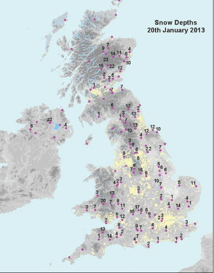
Image 3 below shows the snow depths (cm) on 20 January.
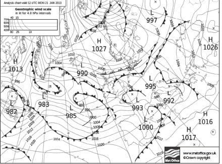
 On 21 January northeast England and eastern Scotland had the heaviest falls of snow and strong southeasterly winds gave blizzard conditions in places. Parts of Northern Ireland were also affected by heavy snow.
Image 4 below shows the weather chart for 12pm on 21 January. Milder air was to the southwest of the UK and cold easterly winds affected the north. The weather front across northern England represents a battle between warm and cold air. The thin black lines (isobars) are lines of equal pressure. Closer spaced isobars give stronger winds.
 Another fall of snow affected southwest England and south Wales on the 22 and 23 January as mild Atlantic air battled with the existing cold air. A final period of snow affected the Midlands northwards on the 25 and 26 January. A further 20 cm fell in places. The snow eventually turned to rain on 26 January with milder southwesterly winds finally becoming established across the UK.
Unsurprisingly, there were low temperatures during this period. Day time temperatures reached 1 or 2 °C at best and overnight temperatures were typically in the range -2 to -5 °C.
The table below shows the snow depths recorded during this period.

Getting the message to people
For many years the public has accessed Met Office forecasts via the TV, radio and newspapers. Now, our social media accounts on Facebook, Twitter, YouTube, Google+ and our News Blog have helped people to access our weather forecasts and warnings. During this cold spell people accessed the Met Office web pages millions of times every day. On 17 January our web pages were viewed over four million times, roughly four times more than normal. People were able to plan, prepare and protect themselves from the impacts of the snow, ice and cold. Our social content was viewed by the Scottish Government, Heathrow Airport and the Highways Agency to name just a few.