Home » Teaching Resources » Case Study – Hurricane Igor (Sept 2010)

Case Study – Hurricane Igor (Sept 2010)

Facebook
Twitter
Pinterest
Print

A Met Office forecaster was working on secondment in Bermuda during
hurricane Igor. Some thoughts were gathered from somebody who experienced
it in person.

What is a hurricane?

A hurricane is a storm system which has a large low pressure centre. They produce heavy rain and have strong winds. To be classed as a hurricane the mean (as opposed to gust speeds) wind speeds must be in excess of 74 mph. The table below shows the Saffir-Simpson hurricane scale.

igot table

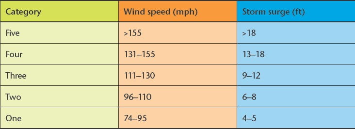
A hurricane with a wind speed of 74 mph is classed as a Category 1 hurricane. Category five hurricanes have wind speeds in excess of 155 mph. As well as heavy rain and intense wind hurricanes are traditionally accompanied by storm surges. Hurricanes form over warm tropical seas where the sea surface temperature is at least 27 °C. Moist air and converging winds are also required. Most hurricanes initially form to the west of Africa. As the hurricane develops it forms a clearly defined eye.

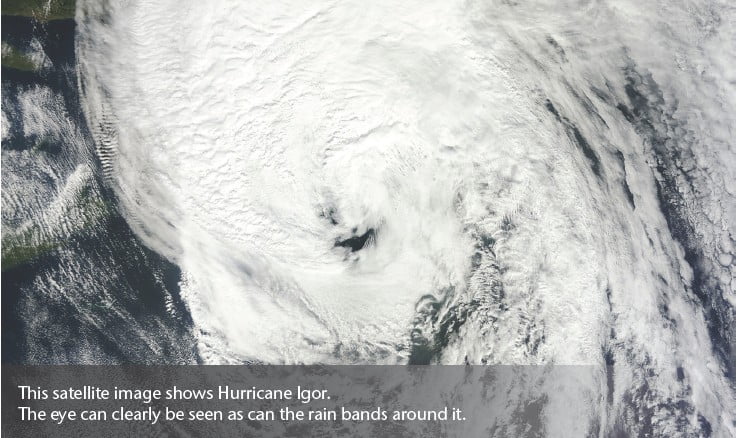
This satellite image shows Hurricane Igor.
The eye can clearly be seen as can the rain bands around it.

igor storm

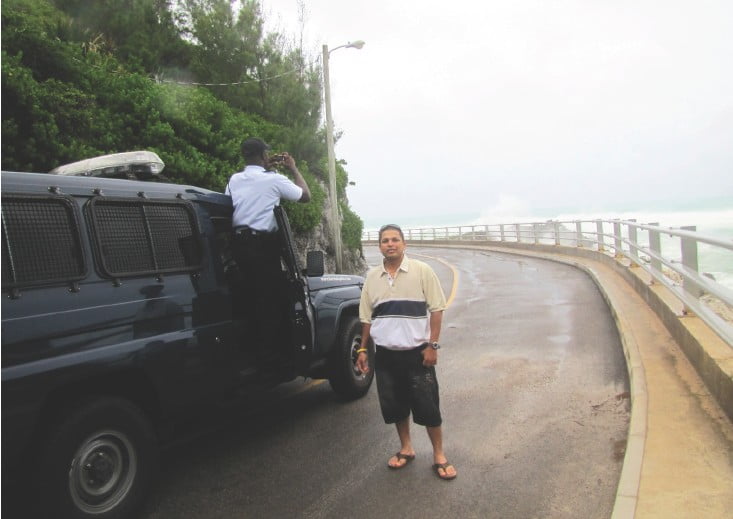
On 17 September Bermuda was placed under a hurricane watch. It was feared that Igor would affect Bermuda as a Category three. On the 20 September Igor passed roughly 40 miles to the west of Bermuda. Winds reached sustained of 91 mph with gusts of 117 mph, in actual fact a Category one hurricane.

The impacts on Bermuda

Every year the Atlantic hurricane season spans from the start of June to the end of November.

Why was Igor in particular chosen for this case study? 

The reason is that Andy, a Met Office forecaster was on secondment with the Bermuda Weather Service and he experienced the full effects of the hurricane. It is good to get some thoughts from someone who experienced the effects in person.

“Hurricane Igor was predicted to be a direct hit on Bermuda. My job was to keep track of the forecasts and warnings for the Bermuda Weather Service, working closely with the National Hurricane Centre. This was exciting but the safety of the Islanders was always a concern. When the hurricane moved near, the noise in the weather centre became immense. The storm proof windows warped and there was a distinct smell of fish from the sea spray. Into the night there were flashes in the distance, which signalled the many downed power lines. Meanwhile reports came in of flooding in St Georges and some boats let loose from their moorings. When Igo finally cleared the Bermuda nobody was injured because they were prepared, thanks to the forecast and the action of government emergency agencies.”

photographing the storm

The main impacts were due to the winds which downed trees and as a result the power supply to around 28,000 people was cut. The airport was closed for 2 days. Several boats were broken from their moorings and damaged on rocks.

No evacuation plans were initiated but a school was converted into a shelter for anyone who felt unsafe. A small number of emergency rescues had to be made but thankfully nobody was hurt.

The main causeway between St David’s and St George’s islands was damaged and one lane was closed for several days.

Tourists were more apprehensive about staying on the island with the majority choosing to leave Bermuda a week or so before Igor’s arrival. A Royal Navy vessel was positioned offshore to assist if required during the hurricane and also in the post-hurricane recovery effort.

The damage was estimated to be less than $500,000. Officials believe that the biggest financial impact of Bermuda was vastly reduced income from tourism. With so many tourists choosing to leave Bermuda (and many cancelling their trips to Bermuda) during the run-up to Igor this had a major impact on hotel and restaurant trade etc.

Web page reproduced with the kind permission of the Met Office

Start exploring

Latest from blog

Related resources …
Secondary Geography
Information about depressions and anticyclones
Secondary Geography
Looking at the relationship between pressure and rainfall and challenging the assumption that low pressure is the only reason for rain.
Secondary Geography
Evidence based activity looking at salt marsh development to protect land from rising sea levels.