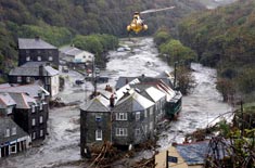

What happened to cause this event?
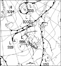
Weather map Fig. 1 shows the weather map for midday on 16 August. The wind is blowing anticlockwise about the low pressure area, so the air is arriving into Boscastle from a south-westerly direction. It is a warm and moist tropical maritime air mass. The line labelled (known as a trough line) caused very heavy rain and thunderstorms. A trough is an area of localised rain and thunderstorms. A line of convergence formed near the coast line, where air moving in almost opposite directions collides, this helped to increase the rate of ascent and produced very heavy rain. There is more about surface pressure charts in the weather section of the Met Office website.Weather chart
Radar imagery
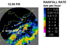
Fig. 2 shows radar pictures at 12 p.m. (midday) on 16 August.
The rainfall rate key shows how the colours in the image relate to the rate the rainfall is falling. For example, the red areas indicate that rain is falling at between eight and 16 mm per hour.
A line of very heavy rain starts at about 1 p.m. on the moors close to Boscastle. It remains over the area for about six hours. Rainfall rates of at least 32 mm per hour are being measured.
There is more about rainfall radar in the weather section of the Met Office website.
Satellite imagery
Fig. 3 shows an animation of satellite pictures from 12 p.m. (midday) to 7 p.m. on 16 August.
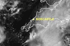
The thickest cloud is shown by the brightest white areas on the picture. The pictures show cloud forming over Boscastle at about 1 p.m. and staying there for much of the afternoon.