Home » Teaching Resources » Anticyclones, Depressions and Fronts

Anticyclones, Depressions and Fronts

Facebook
Twitter
Pinterest
Print

LESSON PLAN: Introduction to Anticyclones, Depressions and Fronts
Key Stage 4 – GCSE
Subject Geography


Length 1 lesson

Teaching Objectives/Learning Outcomes
By the end of the lesson, pupils will know and understand:
Characteristics of depressions and fronts and the sequence of associated weather
Characteristics of anticyclones and the contrast between those in summer and in winter.

Resources Required
None.

Prior Knowledge Required
A basic knowledge of weather and climate

Teaching Activities
The following web pages have related resources at a similar level:

Weather Systems

Student Charts

Weather Systems

Exercises
4 worksheets with exercises are provided to consolidate learning.
A series of extension exercises are provided for more able students, or those who have already studied the topics covered in more detail prior to this lesson.

Plenary – A quiz is available, which brings together all the topics covered. The can be used to examine whether the objectives of the lessons have been met.

Suggestions for Home Work
Any of the worksheet activities can be completed as homework.

PART A – ANTICYCLONES AND DEPRESSIONS

High Pressure Systems

A high pressure system, also known as an anticyclone occurs when the weather is dominated by stable conditions. Under an anticyclone air is descending, forming an area of higher pressure at the surface. Because of these stable conditions, cloud formation is inhibited, so the weather is usually settled with only small amounts of cloud cover. In the Northern Hemisphere winds blow in a clockwise direction around an anticyclone. As isobars are normally widely spaced around an anticyclone, winds are often quite light.
Anticyclones can be identified on weather charts as an often large area of widely spaced isobars, where pressure is higher than surrounding areas.

Winter Anticyclones

In winter the clear, settled conditions and light winds associated with anticyclones can lead to frost and fog. The clear skies allow heat to be lost from the surface of the earth by radiation, allowing temperatures to fall steadily overnight, leading to air or ground frosts. Light winds along with falling temperatures can encourage fog to form; this can linger well into the following morning and be slow to clear. If high pressure becomes established over Northern Europe during winter this can bring a spell of cold easterly winds to the UK.

Summer Anticyclones

In summer the clear settled conditions associated with anticyclones can bring long sunny days and warm temperatures. The weather is normally dry, although occasionally, very hot temperatures can trigger thunderstorms. An anticyclone situated over the UK or near continent usually brings warm, fine weather.

Low Pressure Systems

A low pressure system, also known as a depression occurs when the weather is dominated by unstable conditions. Under a depression air is rising, forming an area of low pressure at the surface. This rising air cools and condenses and helps encourage cloud formation, so the weather is often cloudy and wet. In the Northern Hemisphere winds blow in anticlockwise direction around a depression. Isobars are normally closely spaced around a depressions leading to strong winds.
Depressions can be identified on weather charts as an area of closely spaced isobars, often in a roughly circular shape, where pressure is lower than surrounding areas. They are often accompanied by fronts.

What to do next
Using this information on pressure systems you should now be able to complete worksheet 1. Then you can move on to extension exercise 1 or worksheet 2

  • PART B – FRONTS

A front is a boundary between two different types of air masses, these are normally warm moist air masses from the tropics and cooler drier air masses from polar regions. Fronts move with the wind so over the UK they normally move from west to east. The notes below provide information about the most common types of fronts. The descriptions given apply to active well developed fronts, weaker fronts may not display all the characteristics or they may be less well defined.

Warm Fronts

A warm front indicates that warm air is advancing and rising up over the colder air. This is because the warm air is ‘lighter’ or less dense, than the cold air. Therefore warm fronts occur where warmer air is replacing cooler air at the surface. As the warm front approaches there is a gradual deterioration in the weather. Clouds gradually lower from higher cirrus, through altostratus, to stratus and nimbostratus at the front. There is often a prolonged spell of rainfall which is often heavy. Behind the warm front the rain becomes lighter, turns to drizzle or ceases, but it remains cloudy. 

 Temperatures rise behind the warm front and winds turn clockwise, also known as a wind ‘veer’. 

Pressure falls steadily ahead of and during the passage of the warm front, but then rises slowly after its passage. 

 The following diagram shows the formation of a warm front in diagrammatic form.

PART B – FRONTS A front is a boundary between two different types of air masses, these are normally warm moist air masses from the tropics and cooler drier air masses from polar regions. Fronts move with the wind so over the UK they normally move from west to east. The notes below provide information about the most common types of fronts. The descriptions given apply to active well developed fronts, weaker fronts may not display all the characteristics or they may be less well defined. Warm Fronts A warm front indicates that warm air is advancing and rising up over the colder air. This is because the warm air is ‘lighter’ or less dense, than the cold air. Therefore warm fronts occur where warmer air is replacing cooler air at the surface. As the warm front approaches there is a gradual deterioration in the weather. Clouds gradually lower from higher cirrus, through altostratus, to stratus and nimbostratus at the front. There is often a prolonged spell of rainfall which is often heavy. Behind the warm front the rain becomes lighter, turns to drizzle or ceases, but it remains cloudy. Temperatures rise behind the warm front and winds turn clockwise, also known as a wind ‘veer’. Pressure falls steadily ahead of and during the passage of the warm front, but then rises slowly after its passage. The following diagram shows the formation of a warm front in diagrammatic form.

The following diagram shows a cross section through a warm front, with associated cloud, temperature and weather changes.

warm front

Cold Fronts

A cold front indicates that cold air is advancing and pushing underneath warmer air at the surface. This occurs because the cold air is ‘heavier’ or denser than the warm air. Therefore cold fronts occur where cooler air is replacing warmer air at the surface. The passage of weather associated with a cold front is much shorter lived than that with a warm front. As there is often a lot of cloud in the warmer air ahead of the cold front, there is often little indication of the approaching cold front. 

As the front passes temperatures fall and there is often a short spell of very heavy rain, sometimes with inbedded thunderstorms and cumulonimbus clouds. Behind the front the weather is much brighter with broken clouds but occasional showers. Winds veer with the passage of the cold front and are often strong and gusty, especially near showers. 

Pressure rises throughout the approach and passage of the cold front. 

The following diagram shows the formation of a cold front in diagrammatic form.

anticyclones_depressions_fronts_3

The following diagram shows a cross section through a cold front, with associated cloud, temperature and weather changes.

cold front

Occlusions

In a mature depression the warm front normally precedes the cold front. Cold fronts generally travel much quicker than warm fronts, and eventually it will catch up with the warm front.

Where the two fronts meet, warm air is lifted from the surface and an occlusion is formed. An occlusion can be thought of as having similar characteristics to both warm and cold fronts.

The weather ahead of an occlusion is similar to that ahead of a warm front, whilst the weather behind is similar to that behind a cold front.

The following diagrams depict the formation of an occlusion.

anticyclones_depressions_fronts_5
anticyclones_depressions_fronts_6

What to do next:

You can now move on to Part C – Life Cycle of a Depression.

PART C – LIFE CYCLE OF A DEPRESSION

A Norwegian scientist called Vilhelm Bjerknes devised a simple model which described how depressions developed from the meeting of warm and cold air. The model had four stages which are detailed below.

Origin and Infancy

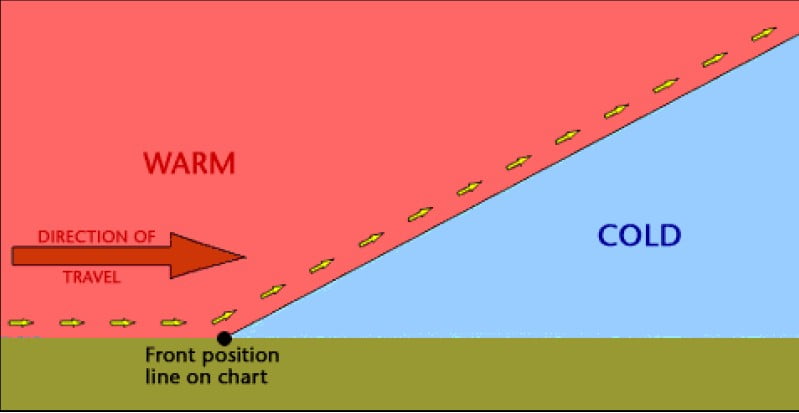
Initially a warm air mass such as one from the tropics, meets a cooler air mass, such as one from the polar regions. Depressions which affect the UK normally originate over the Atlantic Ocean.
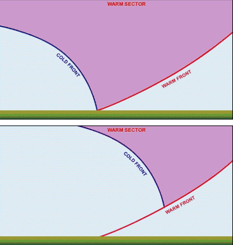
anticyclones depressions

Maturity

The warm air rises up over the colder air which is sinking. A warm sector develops between the warm and cold fronts. The mature stage of a depression often occurs over the UK.
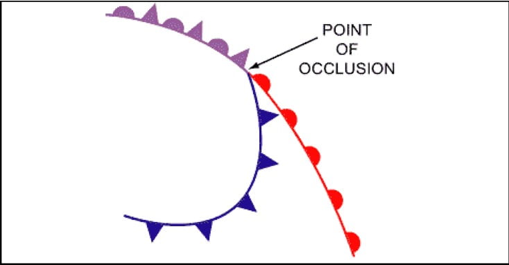
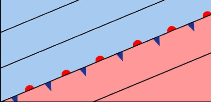
anticyclones depressions fronts

Occlusion

The cold front travels at around 40 to 50 miles per hour, compared to the warm front which travels at only 20 to 30 miles per hour. Therefore the cold front eventually catches up with the warm front. When this occurs an occlusion is formed.
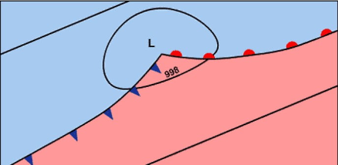
anticyclones depressions fronts

Death

Eventually the frontal system dies as all the warm air has been pushed up from the surface and all that remains is cold air. The occlusion dies out as temperatures are similar on both sides. This stage normally occurs over Europe or Scandinavia.

What to do next
You can now move on to Part D – Depression cross-section and weather sequence

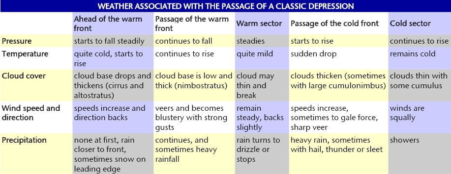
PART D – DEPRESSION CROSS SECTION AND WEATHER SEQUENCE

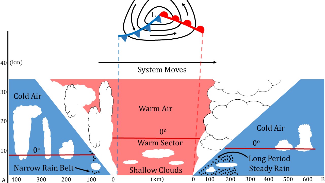
Cross-section through a Classic Depression

Most depressions have a warm and cold front, more mature depressions may also have an occluded front. The diagram below shows a cross-section through a depression, showing the warm and cold fronts and an indication of the associated weather.

cross section through a depression

table

What to do next

Using this information on the passage of depressions you should now be able to complete worksheet 3 and worksheet 4.

Web page reproduced with the kind permission of the Met Office

Start exploring

Latest from blog

Related resources …
Secondary Geography, Secondary Science
Frequently Asked Questions from the IPCC 2013 Fifth Assessment Report
Secondary Geography
In this lesson we investigate the factors which can help create a microclimate and introduce fieldwork opportunities within the school grounds.