Climate Change Graph


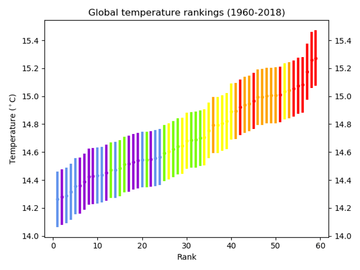
You will need: 120 multicoloured lollipop sticks (at least 10 sticks each of 6 colours), PowerPoint, lollipop.xls, blue tack or similar

  1. Beforehand, mark on the middle of each lollipop stick. On each stick, write the year and the temperature for one of the data points in the spreadsheet (e.g. 1970 14.47), differentiating between global and CET data. Use a different coloured lollipop for each decade – so the 60s are all one colour etc.
  2. You’ll also need to print a blank graph – the spreadsheet supplied will work on A3 paper.
  3. Divide the students into two groups. Within each group, divide out the lollipop sticks.
  4. They should then work together to stick the sticks to the graphs in the right places.
  5. When they’ve finished, ask them to complete the table on the ppt.
  6. What does their graph show? What surprises them? What are the similarities and differences between the graphs?
  7. Next, they should take the sticks back off the graph and, within their groups, line the sticks up in temperature order with the coldest on the left and the warmest on the right.
  8. What does this show?

Transition Resources for Year 6/ Post SATS

Transition Resources for Year 6/Post SATS

These resources are designed to be used in one session with year 6 (10/ 11 year old) students. Although they will support numeracy, literacy and various other aspects of the curriculum, they are designed to prepare students for secondary school rather than support the year 6 curriculum.

There are 6 suggested activities. Although they are designed to be run sequentially, you may choose to use only some of the activities, or to supplement them with your own ideas.
It should be possible to use these activities with any class size.

Many people, including Ellie Highwood, Cristina Charlton-Perez, Helen Johnson and Laila Gohar, have contributed to these resources.

Guidance Notes – START HERE!

Activity 1 – the Difference between Weather and Climate

Powerpoint: Weather-or-Climate

Word Doc: Weather-or-Climate

Activity 2 – Climate Change Graphs

Powerpoint: Climate Change Picture

Excel: Lollipop

Activity 3 – Climate Change Lucky Dip

No resources required

Activity 4 – Weather Risk Game

Powerpoint: Weather Risk Game

Word Document: Money

Activity 5 – Flooding/ Floating Gardens

Powerpoint: Floating Garden Challenge

Activity 6 – Greenhouse Bulldog

No resources required

Does it Always Rain from Dark Clouds?

Severe Storms

Including hail, downdraughts and cloudbursts

hailstructure
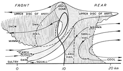
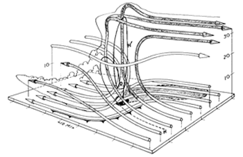
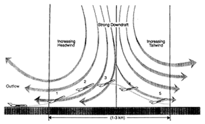
It was reported in The Times newspaper on 15 April 1986 that a hailstorm lashing Dhaka, the capital of Bangladesh, had killed nearly 50 people and injured more than 400. The storm had brought winds of about 60 mph and hailstones weighing up to 2 lb (nearly 1 kg). Houses had been flattened, communications disrupted and the windscreens of more than 700 cars shattered. In such conditions, an umbrella was no use whatsoever; even a riot shield may not have provided adequate protection! According to Dick File, in Weather Facts (Oxford University Press, 1991), this storm (which struck on 14 April 1986) killed 92 people and produced hailstones that weighed 1.02 kg.

The heaviest hailstones to fall on the United Kingdom did so at Horsham, West Sussex, on 5 September 1958 and weighed 140 g. They were almost the size of a tennis ball. When they hit the ground, they were travelling at speeds in excess of 100 mph (50 m/s). If you find this surprising, do a little calculation, using the formula:
V2 = u2 + 2as where u is the initial speed, v the terminal speed, a the acceleration (in this case, due to gravity) and s the distance travelled. For a hailstone falling from a height of 500 m through still air, v = 100 m/s! The impact of a missile the size of a tennis ball travelling this fast is much more serious than that of a cricket ball hit for six.

Should you ever get the chance, collect some large hailstones and cut them in half. You may find a layered structure, with alternate layers of clear and opaque ice (as in the picture on the right, which shows a section of a hailstone viewed by transmitted light). The layers are acquired in different parts of the storm clouds. As hailstones fall, they collect tiny water droplets, which flow around them and freeze. If no air is trapped, the ice is clear.

The storm which struck the Wokingham area of Berkshire on 9 July 1959 produced hailstones more than 2.5 cm in diameter. This storm was studied in detail by Professor Frank Ludlam of Imperial College and his team of co-workers, who produced a striking three-dimensional model of the airflow with-in the storm and explained how large multi-layered hailstones may form in such weather systems.

diagram of severe storm 3
This three-dimensional model is taken from a paper entitled Airflow in convective storms by K.A.Browning and F.H.Ludlam published in the April 1962 issue of the Quarterly Journal of the Royal Meteorological Society (Volume 88, pp.117-135).

In the diagram on the right, streamlines of air in which condensation occurred are shaded. The surface areas affected by rain and hail are shown by, respectively, grey and black shading. Heights are shown in thousands of feet. Precipitation formed in air which entered the storm near position H. As shown, the precipitation was carried across relative to the storm to around 13-15,000 feet, whereupon it fell and re-entered the strong updraught near posit-ion O. Some precipitation particles reached altitu-des of 30,000 feet or more and grew into large hail-stones before falling again, forward of the strong updraught, near position H’. The storm moved from left to right, with rain on its left flank and a squally ‘gust front’ (shown as a cold front) on its right flank. Behind the storm, chilled air reached the ground.

severe storm diagram

The diagram on the right shows a vertical section through a typical severe hailstorm (moving from right to left) and is also taken from Ludlam’s 1961 article in Weather. Compare this diagram with the three-dimensional model above

The paths of the air are drawn as if the storm was stationary. They are, therefore, relative streamlines. The dashed lines are trajectories of small hailstones. The thick full line shows the trajectory of a large hailstone.

To some extent, the features shown on this vertical section occur also in vigorous cumulo-nimbus systems which do not produce large hail. Students can look out for mamma, the udder-like cloud feature that hangs under the anvil and other parts of the cloud. How are mamma formed? Students can also observe gust fronts and measure the temperature drop that occurs when a storm passes. It is often several degrees Celsius. Perhaps, with the help of someone who has a car, they can map areas of rain and hail relative to moving storms.

severe storm diagram 2
This diagram has been taken from The microburst hazard to aircraft by J.McCarthy and R.J.Serafin, published in Weatherwise in 1984 (Volume 37, pp.120-127)

In severe storms, downdraughts may be as strong as 30-40 m/s and reach the ground as ‘down-bursts’. These are dangerous, as the diagram above shows. Downbursts spread out near the ground. An aeroplane that flies into such an outflow first encounters an increasing head-wind (at 1 and 2), which adds to the speed of the speed of the air flowing over the aircraft’s wings and thus increases lift. At 3, however, the strength of the downdraught begins to reduce the altitude of the aircraft; and at 4 and 5 the aircraft experiences both a tail-wind (which reduces air speed and lift) and a downward force from the downdraught. Over the years, there have been many air disasters caused this way, especially in North America.

Cloudbursts

On 15 August 1952, the village of Lynmouth in North Devon was devastated by a torrent of water which poured off Exmoor; 34 people died. On 29 May 1920, in and around the Lincolnshire town of Louth, 22 people died when water from a storm over the Wolds caused the River Lud, normally a small stream, to rise 5 m above its normal level. In Dorset and Somerset, there have been similar occurrences; and in all cases, severe storms caused the havoc. When such storms occur in the British Isles, the wind in the upper troposphere is typically from the south-west, with the wind in the lower troposphere from a north-easterly point (and pressure low to the south and south-west). If this flow is lifted orographically, the storm may become stationary and deposit several inches of rain in a short time. Thus, it is places below slopes that face northwards or north-eastwards that are most at risk.

Hail Prevention

To frighten away the evil spirits that caused hail, primitive tribes used to shoot arrows into storm clouds; and Christians have tried to exorcise these spirits by ringing church bells (a dangerous practice because of lightning strikes on bell towers). Not only arrows, but also cannon-balls, artillery shells and rockets have been fired into storm clouds, but all to no avail. Though there is some evidence that cloud seeding may help to reduce the size of hailstones, there is nothing we can yet do to prevent the formation of severe storms.

Climate Change Resources

Summary of Weather and Climate Links in the 2014 KS2 National Curriculum
Curriculum Links
Year 4 Scheme of Work Plants  Literacy
Year 3/ 4 Scheme of Work Climate zones
Year 5/6 Scheme of Work Climate zones Science – Light, Fossils

General Resources


Diamond Ranking sheet

Acknowledgements

The Climate Change Schools Resources were developed by the Climate Change Schools Project, based at the then Science Learning Centre in Durham and led by Krista McKinzey. A large number of teachers and schools in North East England were involved in their development.

They have subsequently been updated by the Royal Meteorological Society.

Recommended Weather Resources for KS2

Recommended Weather Resources for teaching 7-11 year olds

BBC What is Weather animations and lesson plans for KS2 weather.

Weather for Schools resources.

Weather resources from the Primary Magazine from the National Centre for Excellence in the Teaching of Mathematics. Requires free registration on the national STEM database.

A nice interactive map showing hot and cold extreme temperatures which introduces GIS techniques.

Seasons resource from ngfl-cymru.

A nice interactive resource for weather forecasting, focussed on Wales.

Recommended Climate Resources for KS2

Recommended Climate Resources for teaching 7-11 year olds

What’s Changing our Climate: Children’s Christmas Lecture from Imperial College London, with Professor Jo Haigh, 2017.

From the GA Investigating Climate Zones and Climate Change.

Windows to the Universe – climate.

UCAR – kids crossing.

CAFOD: zero hero campaign

Using Automatic Weather Station Data

Lesson title: Using weather data to record, interpret and predict the weather (Part 1)

Drawn from National Curriculum Key stage 2 Geography:
Geographical enquiry and skills

1 In undertaking geographical enquiry, pupils should be taught to:
Analyze evidence and draw conclusions
2 In developing geographical skills, pupils should be taught:
to use secondary sources of information, including aerial photographs [for example the internet,]
Knowledge and understanding of patterns and processes
3 Pupils should be taught to recognize and explain patterns made by individual physical and human features in the environment

Key Stage 2 Mathematics – National Curriculum

Solving numerical problems

Pupils should be taught to:
choose, use and combine any of the four number operations to solve word problems involving numbers in ‘real life’

National Curriculum – Sc1 Scientific enquiry

a) use a wide range of methods, including diagrams, drawings, tables, bar charts, line graphs and ICT, to communicate data in an appropriate and systematic manner

Considering evidence and evaluating

i) make comparisons and identify simple patterns or associations in their own observations and measurements or other data
ii) use observations, measurements or other data to draw conclusions

Learning objectives:

  • To be able to use secondary sources of information, including aerial photographs [for example the internet]
  • To be able to analyse evidence and draw conclusions
  • To be able to recognise and explain patterns made by the data leading to basic predictions

Agree or Disagree – Weather Misconceptions

Agree or Disagree?

Originally developed by Debbie Myers, Teaching Fellow, Durham University and
AstraZeneca Primary Science College member.

  1. Cards to generate discussion and to identify students’ misconceptions about the weather.
  2. Cut out the cards and ask the students to place them on a Agree/Unsure/Disagree Continuum.
  3. Suggested answers available below. As an extension exercise, students could be asked to look up evidence to support their answers, particularly for the ‘unsure’ cards. The quality and reliability of sources could also be discussed.

Global Winds Treasure Hunt

Supporting article from Primary Geography.

Overview

Print off and laminate the names of enough winds. Hide them in the classroom or in the school grounds. As the students individually, in pairs or small groups to find a wind. They should then research the wind they have found, answering questions like:

– Where is the wind found? Use an atlas or Google Earth to find the place and see how the
local geography affects the wind (are there mountains nearby?)
– When does the wind occur?
– How long does it last for and how big is the area it affects?
– Do people like this wind?

Their research could be presented using PowerPoint or large sheets of sugar paper, and/ or could be used as the basis for a story or newspaper report about the wind.