This morning, skies were orange/ beige across much of England as a Tropical continental (Tc) air mass brought Saharan dust.

Image credit: Geoff Jenkins
Read more about why the air was carrying so much dust, and see some stunning photos from Spain and France here. The further the air travelled, the more dust was deposited and the less dust remained in the air – so the most vivid skies were in the south.
Read our guide to air masses for background information or show our YouTube explainer.
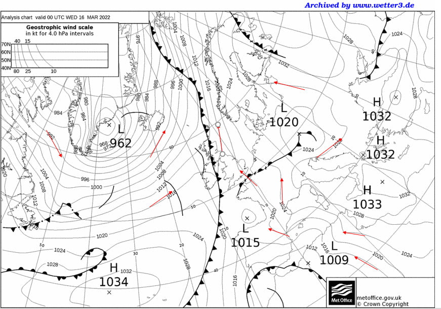
How can you tell that there is Tc air from this weather chart (midnight on 16th March 2022)?
The air approximately follows the isobars, shown as thin lines on this chart. To work out which way, you need to look at the pressure systems and remember that air goes clockwise around anticyclones (H) and anticlockwise around cyclones (L).
Considering either the 962mbar Low or the 1033mbar High shows you that the air is coming from the south (a southerly wind) across England.
Following the isobar marked 1020 back, you can see that the air has come over Spain from Africa. This is a Tropical continental air mass.
Behind the occluded front, for much of Ireland, the wind coming from the west. The 1020mbar Low is a bit misleading, but you can see that the air coming up from the south diverts to curve round it in an anticlockwise flow.